

 Image 1 of 3
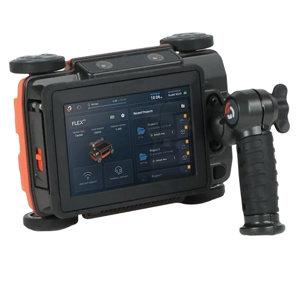 Image 2 of 3
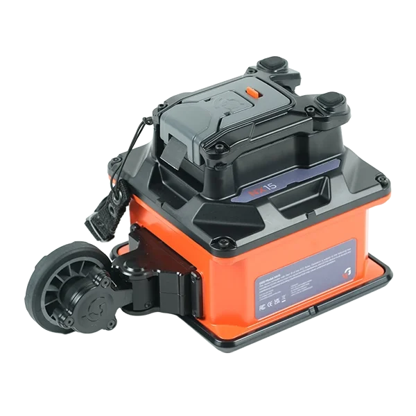 Image 3 of 3

Authorized Distributor for:
The Caribbean, Central America, and South America
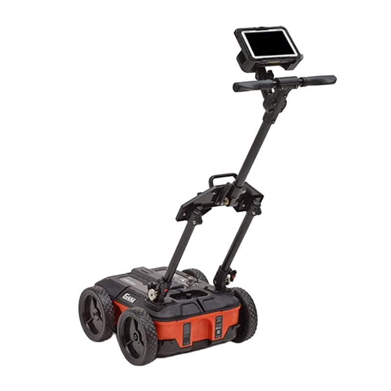
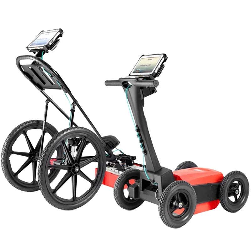
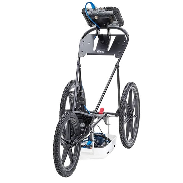
UtilityScan Pro | Industry Standard in GPR for Utility Mapping and Locating
With UtilityScan Pro, users can quickly identify and mark the position and depth of metallic and non-metallic objects; including utilities such as gas, communications and sewer lines as well as underground storage tanks and PVC pipes. Based on the SIR 4000 controller, the UtilityScan Pro provides the GPR professional with solutions to any underground locating situation.
Max Depth: 0 -12 Meters (0 -40 Feet)
Antenna Options: 400 MHz, 300/800 DF, 350 HS
Weight: 27.2-34 kg (60-75 lbs) (cart dependent)
Storage Capacity: 32 GB
Optional Software: RADAN 7 for UtilityScan, RADAN 7
Accessories: LineTrac, Juniper Geode GPS, Tripod for 3-wheel survey cart
Typical Uses
Underground utility detection
Environmental remediation
Damage prevention
Geological investigation
Archaeology
Forensics
Road inspection
System Includes
SIR 4000 Control Unit
400 MHz, 300/800 DF, or 350 HS Antenna
Choice of 3-wheel or 4-wheel cart
2 m control cable
SIR 4000 sunshade
SIR 4000 AC/DC power supply
Lithium-ion battery (2)
Dual-bay battery charger
Transit case
2-year warranty
UtilityScan | GPR System Optimized for Utility Locating
Locating and marking underground utilities in real-time in the field has been a powerful application of ground penetrating radar (GPR) for many years. A knowledgeable utility locator with a GPR system as part of their toolbox is able to accurately identify buried utilities. UtilityScan is built for the utility locating professional to accelerate workflow from target detection to reporting.
Max Depth: 10 Meters (35 Feet)
Antenna Options: 350 MHz
Weight: 16.8 kg (37 lbs)
Storage Capacity: 512 GB
Optional Software: RADAN 7 for UtilityScan, RADAN 7
Accessories: Geode GPS, Transit case, Model 626 survey cart, Model 656 survey cart
Typical Uses
Scan utilities – metallic and non-metallic
Locate water lines
Detect voids and underground storage tanks (USTs)
Identify soil and foundation characteristics
Locate shallow objects for archaeology
System Includes
350 HS antenna (350 MHz)
Panasonic G2 Toughpad
Lithium-ion battery (2)
Dual-bay battery charger
Rugged 2 m ethernet cable
LineTrac, optional
Sunshade for G2 Toughbook
Quick Start Guide
2-year warranty
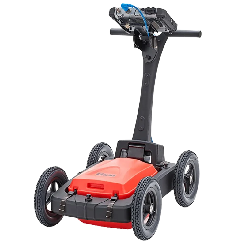
UtilityScan DF | Locate and Map Underground Utilities
UtilityScan DF incorporates our innovative dual-frequency digital antenna (300 and 800 MHz) and an easy-to-use touchscreen interface to view shallow and deep targets simultaneously in a single scan.
Max Depth: 7 Meters (21 Feet)
Antenna Options: 300/800 MHz
Weight: 51-66 lbs (cart dependent)
Storage Capacity: 128 GB
Optional Software: RADAN 7 for UtilityScan, RADAN 7
Accessories: Sunshade for Panasonic G2, LineTrac
Typical Uses
Utility detection
Environmental assessment
Damage prevention
Geological investigation
Archaeology
Forensics
Road inspection
System Includes
300/800 MHz DF antenna
Panasonic G2 Toughpad
Choice of 2-wheel or 4-wheel cart
2 m digital control cable
Transit case
Lithium-ion battery (2)
Dual-bay battery charger
2-year warranty

FLEX NX | The Most Complete Concrete Scanning System
Flex NX®, powered by Nexus™ is the industry’s most powerful and efficient concrete scanner. The all-in-one design offers a large and integrated touchscreen display, providing intuitive interface with minimal navigation.
Data collection modes harness the power of simultaneous standard and cross-polarized antennas, Flex Mode for quick prospecting and no grids required, and Flex Grid for structured, grid-based scanning to support real-time mark outs and post-processing workflows. Flex NX also allows you to view your data on a paired phone or tablet.
Use Flex NX on its own, or pair an NX25 or NX15 wireless antenna for a flexible solution to any concrete scanning problem. When you’re done, simply upload your results to GSSI Fusion and quickly create an informative and great-looking report.
System Includes
Flex NX with adjustable handle
Lithium-ion 3-cell battery (2) for Flex NX/LT
Dual-bay battery charger
Rugged Transit Case or Flex NX/LT Backpack (Please Select Below)
Wrist strap
Flex NX/NX25/NX15 Quick Start Guide

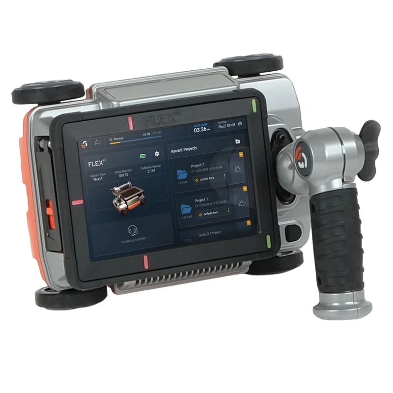
FLEX LT | Built for Mark-and-Go Scanning
Flex LT, powered by Nexus, is GSSI’s newest handheld concrete scanning system. This system is a perfect solution for contractors who need to locate and mark targets with speed and precision, without sacrificing quality or budget.
The all-in-one design features a large integrated touchscreen and intuitive interface for minimal navigation. Using simultaneous standard and cross-polarized antennas, it provides clearer, more detailed data for precise scanning on the jobsite. On Flex LT, you have the availability to do 3D data collection with Flex Grid.
Ideal for locating rebar, post-tension cables, pipes, and voids, this system helps contractors make informed decisions, reduce risks, and improve project outcomes. Whether for small renovations or large construction projects, it offers reliable real-time insights into concrete structures, boosting productivity.
System Includes:
Flex LT with adjustable handle
Lithium-ion 3-cell battery (2) for Flex NX/LT
Dual-bay battery charger
Rugged Transit Case or Flex NX/LT Backpack (Please Select Below)
Wrist strap
Flex LT/NX25/NX15 Quick Start Guide

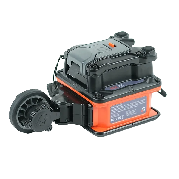
NX25 Antenna | Small Area System
NX25™ powered by Nexus™, makes scanning easier than ever. This lightweight and compact antenna is purpose -built for reaching difficult areas such as walls, ceilings, and scanning tight spaces. With its intuitive design, the new Nexus Elements™ Interface simplifies routine tasks and ensures that even basic operations are seamless and efficient.
Whether you’re a contractor, engineer, or technician, the NX25 Small Area System is ideal for anyone who requires reliable, easy-to-use tools for mark and go jobs and wants to maintain productivity on the job.
System Includes:
NX25 antenna with detachable encoder
Lithium-ion 2-cell battery (2) for NX25/NX15
Dual-bay battery charger
NX25/NX15 RAM ball accessory bracket
NX25/NX15 port cover (2)
NX25/NX15 backpack
Wrist strap
Nexus Elements NX25/NX15 Quick Start Guide

NX15 Deep Target System | Engineered for Depth. Built for Performance
FNX15® Deep Target System is designed for inspecting thick concrete, slab-on-grade surfaces, and structural elements. Engineered for enhanced penetration, it offers a depth range of 0–150 cm (0–60 in) in ideal conditions.
NX15 pairs intuitive operation with the new Nexus Elements™ Interface. Its ergonomic form factor allows you to scan, mark, and move quickly from one task to the next, streamlining your workflow on-site.
Whether you’re a contractor clearing locations for deep coring or a technician tracing sub-grade utilities, NX15 delivers the depth and performance you need, giving you fast, reliable insights that reduce risk and keep your projects moving safely and efficiently.
System Includes:
NX15 antenna with detachable encoder
Lithium-ion 2-cell battery (2) for NX25/NX15
Dual-bay battery charger
NX25/NX15 RAM ball accessory bracket
NX25/NX15 port cover (2)
NX25/NX15 backpack
Wrist strap
Nexus Elements NX25/NX15 Quick Start Guide
PaveScan RDM 2.0 | Non-destructive Asphalt Density Testing Equipment
The PaveScan RDM 2.0 is our second-generation asphalt density assessment tool that is ideal for uncovering inconsistencies that occur during the paving process, including poor uniformity and significant variations in density. By detecting these problems, PaveScan RDM 2.0 helps to avoid premature failures such as road raveling, cracking and deterioration along joints.
This pavement density measurement technology is now an accepted AASHTO spec, #PP 98-19.
Max Depth: Surface Only
Sensor Frequency: 2 GHz
Weight: 36.9-42.9 kg (81.4-94.6 lbs)
Storage Capacity: 512 GB
Data Display Modes: Line Graph, Data Contour Map or Histogram Distribution
Accessories: Upgrade kit from 1 to 3 sensors, Geode GPS
Typical Uses
Non-destructive asphalt compaction testing
Quality assurance/quality control of new pavements
Determining pavement non-conformity
System Includes
2 GHz Sensor (1 or 3)
Panasonic Toughpad G2
4-wheel cart
2.1 m digital control cable(s)
Concentrator box
Lithium-ion battery (2)
Dual-bay battery charger
User Manual
2-year warranty
BridgeScan | GPR Bridge Inspection Equipment
BridgeScan™ is a complete, affordable GPR system that is an effective tool for quickly determining the condition of aging bridge decks, parking structures, balconies and other concrete structures. The system is also used to obtain accurate concrete cover depth on new structures.
Max Depth: 30 cm (12 in)
Antenna Frequency: 1600 MHz
Weight: 24.9 kg (55 lbs)
Storage Capacity: 32 GB
Optional Software: RADAN 7 for UtilityScan, RADAN 7
Accessories: No Accessories Needed
Typical Uses
Bridge deck condition assessment
Void detection and location
Measure concrete thickness
Inspection of other reinforced concrete structures
System Includes
SIR 4000 Control Unit
1600 MHz antenna
3-wheel survey cart
2 m control cable
SIR 4000 sunshade
Lithium-ion battery (2)
Dual-bay battery charger
Transit case
RADAN 7 & RADAN 7 BridgeScan Module
2-year warranty